Item NA31 - Sounding
Lead & Line from Down East, Maine.
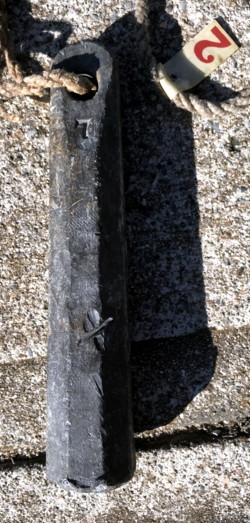
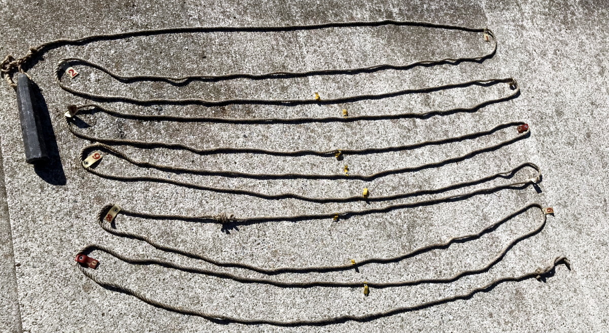
 One
of the principal, yet unheralded navigation tools for the coastal sailor has
long been the sounding lead and line. With a lead weight having a cupped end to
hold tallow, soap or a similar stickysubstance, and attached to a line marked in
fathoms, a captain—even in foul or foggy weather--can quickly determine the
depth of water, and bottom type of the water in which he lies. When this info
is compared with a proper nautical chart (or his memory) his position can be
readily determined, without Radar, GPS, Loran, RDF, or other fancy electronic
gear. This item is such a navigational “instrument.” It came from a fishing
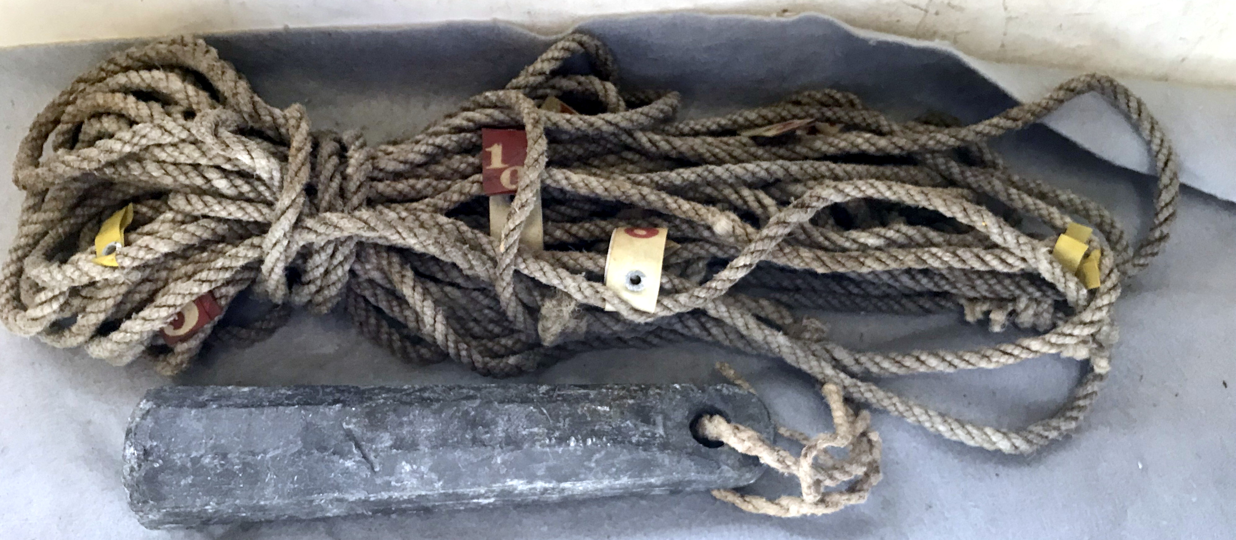
schooner working on the rocky, island strewn coast of eastern Maine. The rig
consist of a typical heaving lead about 9 inches long, and 2 inches diameter.
The lead weighs 7 lbs (and is marked with a “7” at the top, which is cast with a
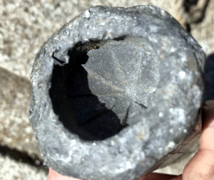
hole for the line. The bottom of the lead is in the form of a deep cup
roughened with chisel cuts to better hold the grease or tallow. When the lead
strikes the bottom, it picks up a sample, sticking to the tallow—mud, fine sand,
coarse sand, gravel, broken shell, etc--so it can be examined on deck. The line
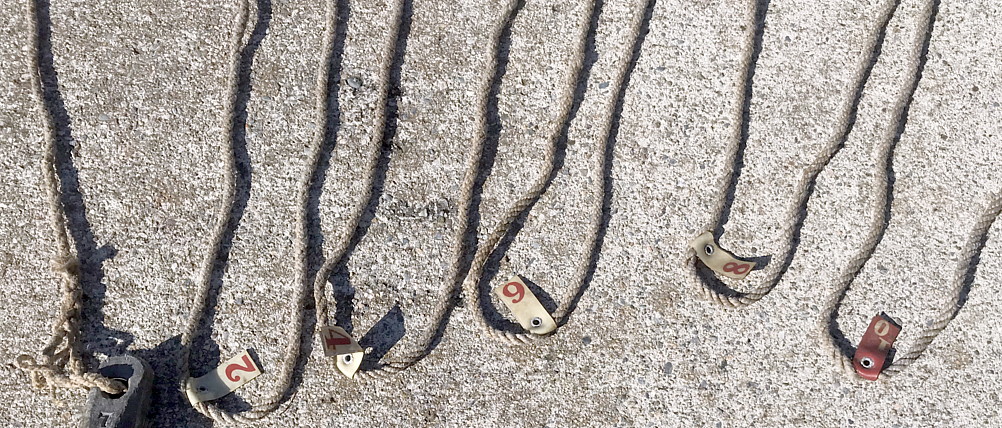
(this one is 3/8” manila or hemp) is marked at 1 fathom (6 foot) intervals. The
markers on this one includes red and white tags inserted between the yarns of
the line, and each marked with the fathom number of the depth. The tags have
been folded over and grommeted so they won’t work loose. Additional
smaller yellow tags mark the 1/2 fathom marks The line is over sixty feet long
and is set to read depths up to 10 fathoms. This gear has seen plenty of use,
the lead weight being dented and knocked, the line as some breaks in the yarn
and some ravelings of the splice. But this is a great example of a real well
used traditional navigational tool. Good+
One
of the principal, yet unheralded navigation tools for the coastal sailor has
long been the sounding lead and line. With a lead weight having a cupped end to
hold tallow, soap or a similar stickysubstance, and attached to a line marked in
fathoms, a captain—even in foul or foggy weather--can quickly determine the
depth of water, and bottom type of the water in which he lies. When this info
is compared with a proper nautical chart (or his memory) his position can be
readily determined, without Radar, GPS, Loran, RDF, or other fancy electronic
gear. This item is such a navigational “instrument.” It came from a fishing
schooner working on the rocky, island strewn coast of eastern Maine. The rig
consist of a typical heaving lead about 9 inches long, and 2 inches diameter.
The lead weighs 7 lbs (and is marked with a “7” at the top, which is cast with a
hole for the line. The bottom of the lead is in the form of a deep cup
roughened with chisel cuts to better hold the grease or tallow. When the lead
strikes the bottom, it picks up a sample, sticking to the tallow—mud, fine sand,
coarse sand, gravel, broken shell, etc--so it can be examined on deck. The line
(this one is 3/8” manila or hemp) is marked at 1 fathom (6 foot) intervals. The
markers on this one includes red and white tags inserted between the yarns of
the line, and each marked with the fathom number of the depth. The tags have
been folded over and grommeted so they won’t work loose. Additional
smaller yellow tags mark the 1/2 fathom marks The line is over sixty feet long
and is set to read depths up to 10 fathoms. This gear has seen plenty of use,
the lead weight being dented and knocked, the line as some breaks in the yarn
and some ravelings of the splice. But this is a great example of a real well
used traditional navigational tool. Good+
Price - $100.00
RETURN to forsale list.