February 28 -- Westport to Lake Moeraki
The trip from Westport to Lake Moeraki is straight down the West Coast of
New Zealand on Rte 6 the entire way. It was just about 400 kilometers, and
took me through the towns of Greymouth and Franz Joseph Glacier, as well as some
smaller places.
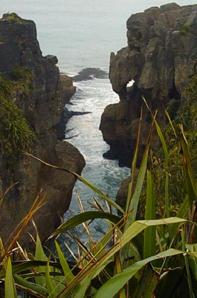
After leaving about 7 in the morning (just about daybreak), I made my first
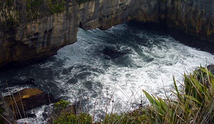
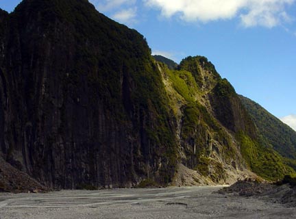
stop about 30 km down the road at a place called Punakaiki. This is the
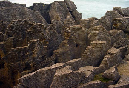
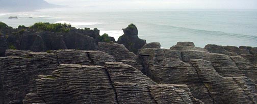
site of a geologic formation known as "Pancake Rocks". These rocks were
formed of layers of sandstone sandwiched with layers of mudstone, and were then
uplifted and eroded by the wind and surf. The effect is interesting, and
it was well worth the visit. Some of the erosion has created caves and
blowholes that spout water when the tide and surf are right. When I was
there, the ocean was fairly calm and I didn't see a spout. That early in
the morning, the only people in the region were three European backpacking kids
in the parking lot, brushing their teeth, so I pretty much had the run of
the place.
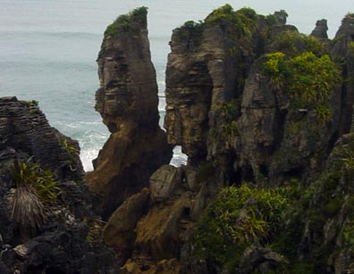
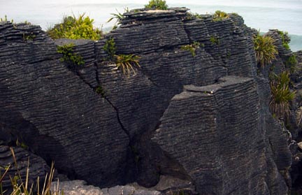 [
[
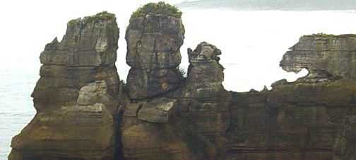
The final formation above is supposed to have a number of animal figures in
it. How many can you see?
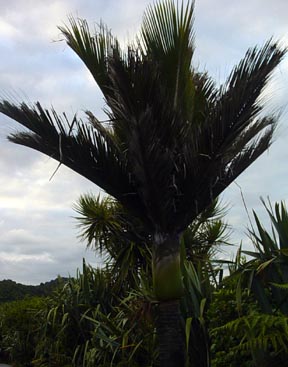
On a natural
history note, around Punakaiki, there are many examples of the Nikau Palm.
There are groves of them along the road. This is the most southerly
occurring natural species of palm tree.
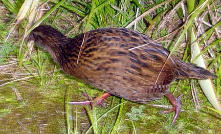 While I was walking
back to the car, I heard a rustling among the New Zealand Flax plants lining the
walkway, and a Weka popped out, right at my feet. Wekas are endemic
flightless birds in New Zealand that are related to the rails of this country.
There are about four varieties or color phases of them found in the country, and
this was the dark brown West Coast variety. It was very tame, and let me
get a good picture of it. Rather shy and retiring, they are tough to find
in the thick cover they inhabit.
While I was walking
back to the car, I heard a rustling among the New Zealand Flax plants lining the
walkway, and a Weka popped out, right at my feet. Wekas are endemic
flightless birds in New Zealand that are related to the rails of this country.
There are about four varieties or color phases of them found in the country, and
this was the dark brown West Coast variety. It was very tame, and let me
get a good picture of it. Rather shy and retiring, they are tough to find
in the thick cover they inhabit.
Down the road a piece from Punakaiki, is the town of Greymouth (located at
the mouth of the Grey River). This is a larger town than
Westport. It is the terminus of the road coming across from east that goes
through Arthur's Pass--a popular route from east to west. It also is the
home of Monteith's Brewery, which makes pretty good beer. It would have
been fun to stop for a brewery tour, but it was still early in the morning (lots
of kids going to school along the road), so I went right through. I also
didn't stop at Hokitika, which is about 40 Km below Greymouth. This is a
center for the jade (greenstone) carving business that is the domain of the Maori's.
The west coast is known for its jade deposits.
The next stretch of road went through fairly flat cattle country, with many
more beef cows than sheep. Just an occasional town (Ross, an old gold
mining place; HariHari, Whataroa, etc.) I did pull over at HariHari and
had a late breakfast, or an early lunch of toast, jam, and hot chocolate. Very
English, and very good.
The road is now a good bit back from the coast, and moved into the hills
again, toward the Glacier towns of Franz Josef Glacier and Fox Glacier (the
English tourists say, "Glah-si-er"). These are receding glaciers that feed
from the Mt. Cook complex of mountains. Mt. Cook is over 12,000 feet high,
and is the tallest mountain, I'm told, between Papua, New Guinea and South
America. It also has come down a bit, losing 66 feet of altitude when
chunk of its summit broke off a few years ago.
The town of Franz Joseph Glacier is a bustling, touristy place with all
sorts of hawkers of helicopter, plane, and bus tours of the glacier. You
can see some of the glacier from the road, but I blew right through town,
preferring to stop at the less traveled Fox Glacier down the road about 25 km.
This was a wise choice, since far fewer people visit Fox Glacier, and the town
is practically non-existent.
After driving for a few kilometers up a dirt access road, you can park the
car along side the rushing stream fed by the glacier and walk about a kilometer
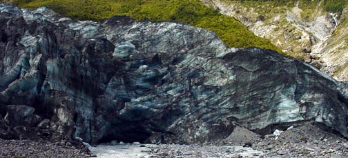
to within a decent distance of the glacier's face. Here are some pictures.
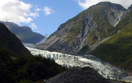
This is how the face of the glacier looks as you first see it, and then
approaching more closely.
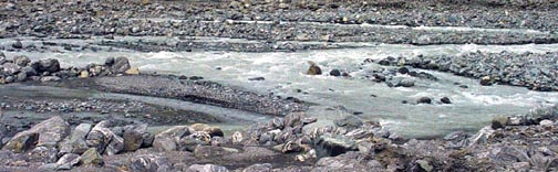
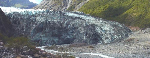
The melt water running out from under the glacier is milky from
the rock that the pressure of the glacier has ground to a flour-like
consistency.
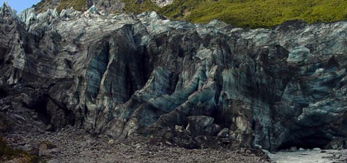
 From
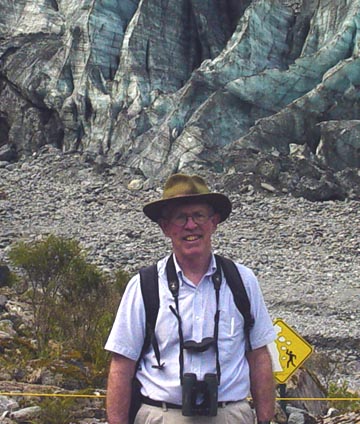
top to bottom, this is what the glacier face looks like from right to left.
And yes, I am in New Zealand, and that is me on the right.
From
top to bottom, this is what the glacier face looks like from right to left.
And yes, I am in New Zealand, and that is me on the right.
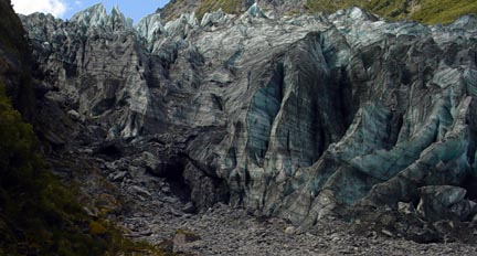
Looking below the glacier's face, the cone-shaped rock on the
right is identifiable in early photographs of the glacier. In 1750 it is
estimated that the top of the glacier was even with the top of the cone, and the
glacier extended a kilometer or more downstream. In 1948 the ice was only
halfway up the cone. Today, the face of the glacier is several hundred
meters upstream..
From Fox Glacier it was a long and lonely drive down the coast
to Lake Moeraki. There is not even a gas station on the route that passes
through almost no villages. But I safely reached the Wilderness Lodge at
Lake Moeraki, about 32 km above Haast. Here, I was greeted sumptuously,
and quickly installed in a wonderful room with amenities and the prospect of
family type meal service with the other guests. To unwind after the 400 km
trip from Westport, I took a 30 minute walk down to Munro Beach on the Tasman
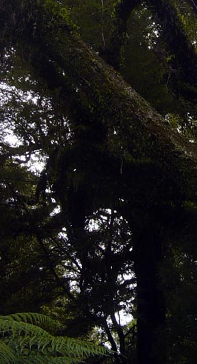
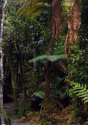
Sea. The track wound through a dark a forbidding rain forest featuring
tree ferns and immense silver beech and rimu trees.
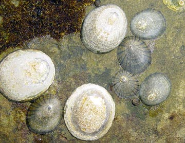
At the beach, the sand flies were ferocious, but I did note the
intertidal rocks were encrusted with limpets--something we don't see on the east
coast at home.
After a wonderful gourmet meal of venison tenderloin, served family style
with great company, a number of guests went along on a short evening nature walk
along the road (rte 6) near the lodge. The objects were to see glow worms
along the shaded road cuts, listen for the local endemic owl, "More Pork", and
to view the Southern Cross constellation. The latter was easily visible,
just 180 degrees from Orion. The New Zealand flag shows this constellation
on a field of dark blue, with a Union Jack in the upper left corner.
Our quest to hear a More Pork, however, was in vein. This is a small
owl, fairly widely distributed, but never common.
The glow worms were easily visible, insect larvae that bioluminesce.
While we usually think of them as cave creatures, they survive in dense
vegetation in places that remain shady all day long.
Waking up before dawn the next morning, I raised my window and did hear a
More Pork calling in the distance. The owl gets its name from its
call--"more pork........more pork". It was higher pitched than I'd
expected.
Tomorrow I'm set for a guided nature walk along an old cattle driving trail
that parallels the Southern Alps Fault line above Lake Moeraki. I'll
report on it.